10/8 Day 76: Sula, MT to Florence, MT 69 miles (3815 miles)
 |
| The sun finally shines on us in the valley. |
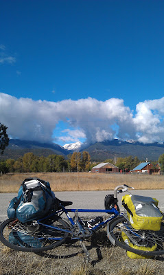
The weather was predicted to warm up today, and stay sunny and pleasant for the day after, as well, so we aimed to get the hell out of Montana. It's not that we didn't think Montana was nice, and not that we didn't like the people, but the cold, rain, and elevation were good motivators for flight. When we woke up in Sula, we found ourselves in another of the frigid mists that seem to envelope every mountain in this state. It was cold enough that in the simple act of packing up the wet, condensation coated tent I had to run to the bathroom and warm my hands over the space heater a couple times just to chase the painful chill of the morning air. We made a simple breakfast of bagels and peanut butter to get us started and we were told by the owners of the campground that the freezing cloud of moisture in the valley would dissipate as we lost elevation and as the day wore on. Sarah told us that she intended to hang out in her tent for a few hours to wait on her riding partners, and to wait out the cold. We bid her goodbye, and sped down into the valley as quickly as possible. The morning was a brisk 39 degrees in Sula, and it slowly warmed as we descended into the Bitterroot Valley. As we neared the next town, Conner, we saw hints and small signs that the sun did, in fact, still exist in some parts of the state, but it wasn't until we reached Darby that we finally had shadows again and could feel warmth once more. I've learned not to take many things for granted on this trip such as running water, walls and roofs, and soft places to sit, but sunlight has been my newest lesson.
 |
A lone ponderosa stands next to
a sun-tipped snowcap. |
As we went lower and lower into the Bitterroot Valley along the Bitterroot River, we began to see things we hadn't seen in thousands of miles. Towns that were less than 30 miles apart, appreciable amounts of trees, and gatherings of people more than 10 strong. We were coming back into a population center, of sorts, and it was refreshing. Since northern Colorado towns and services have been extremely far flung- people as well. Thankfully, being in a group, we have not been starved for company, but the loneliness and desolation one must feel riding alone has to be palpable in the high plains of Wyoming or the arid reaches of Colorado's mountain passes. (As an aside, the weather in Montana has been rainy and cold, but in Wyoming- where we were only a week or two ago- it's snowing in nearly every town we recently passed through. So, it could be worse. West Yellowstone was getting freezing rain...) The towns passed one after the other, but we were gunning for Hamilton, and needed to get there before noon. Much of our motivation for scrambling over the mountains regardless of wind and weather was because of a "The more crappy weather we ride in now, the less crappy weather we have to ride in later" mentality. The other reason was because we needed to pick up our mail that friends, family, and well-wishers had so thoughtfully arranged to have waiting for us in Lolo, MT. We knew days in advance that Lolo might not be achievable before the holiday weekend locked down the postal service, and we got lucky when someone we contacted via warmshowers.org knew a man who worked at the Hamilton post office. This fellow was kind enough to have our mail transferred from Lolo to Hamilton, and get our goods 30 something miles closer.
 |
| Adrift in a sea of loot. Thanks everyone! |
That 30 something miles made all the difference, because we rolled in to Hamilton at 11:45 and 15 minutes before the place shut down for the rest of Saturday, Sunday, and Monday. We were the grateful recipients of at least 9 or 10 packages, and we had our little Christmas celebration out in the post office's lawn. Special thanks again go to my sister Jeanna, and brother-in-law Will, Erin's mom, Ben's parents, Margaret Mazz, Mandi's Mom and Aunt Sue, and Mandi's friends from the Cape for all the baked goods, treats, and knick-knacks, because they really made our day. The sun was finally shining, we had a ton of cookies to eat, and the rest of the day would be mostly flat or downhill. Is there any better outlook for a cyclist? To make things even better, the day had warmed up to a nearly scorching 60 degrees, and we could remove our cold weather apparel. We ate a tasty lunch at a small, artisan sandwich shop in town, and then hit the road in an effort to make it to Lolo for the day. We rode through a number of smal towns in the valley, and were entirely absorbed in the astounding scenery as we rode. The Bitterroot and Sapphire mountains ring the area, and they were breathtaking with the sun shining down on them. The gold grasses and snowy peaks were covered majestically by towering ponderosas and a rainbow of greens comprised of a cornucopia of other evergreens. We rolled through Stevensville, and then to the outskirts of a little town called Florence, where I got another flat tire. Flat number sixteen prompted me to just slap my spare tire and a new tube on the wheel after an hour of dithering about with the damned thing, because I just didn't want to deal with it anymore.
 |
| Barnes: One of a kind guy. |
By that time, the sun was on its way down, and we decided that we should opt for a closer campground than Lolo. We settled on the Chief Looking Glass Campground and Fishing Access, becasue it was only a few miles away and likely free. Upon arrival we made camp, chopped some wood, and made a new friend. Barnes was a North Carolinian who had moved to Montana because it "spoke" to him in a way no other place ever had. He was camping at the campground that night because he refused to pay rent anywhere until he could finally build his cabin in the mountains there in the Bitterroot Valley. Barnes was also a pretty rad guy who was very upbeat, and gave us a bit of 'trail magic' in the form of food. We had a mini potluck that night. We cooked up the pasta and beans that we had, and he offered up the seaweed salad, calamari, and crawdads he had bought earlier at Safeway. We shared some booze, and talked about life on the trail (since he through-hiked the Appalachian Trail in '05) around a nice roaring fire next to the river until it was well into the night. After Barnes headed back to his site, we all crashed out into our tents a bit enlivened by the day and the company, and eager for the next day, which promised to be another rain-less affair.
10/9 Day 77: Florence, MT to Lochsa Lodge, Powell, ID 55 miles (3870 miles)
 |
| Cyclists' Convention at Lolo Pass. |
The night was a very cold one, and our sleep was only interrupted a couple times by roiling yelps and yips of coyotes and one elk bugling in the still darkness. When we woke, the tents, bikes, and everything in sight were covered by a thick, white rime and, yet again, it was cold as hell. We had a hard time even getting out of the tents until the sun dared peek out from behind the trees and wispy mists to grant us a modicum of warmth. Still pacing back and forth around the campsite to stay warm, I ate a very delicious meal of my sister's homemade granola with some whole milk as the sun played peek-a-boo with us. When the light finally did fully emerge, we spread our tents to dry as we leadenly arranged our things for the day ahead. Once packed, we said our goodbyes to Barnes, and it was off to conquer our final mountain pass: the Lolo Pass at 5,200 feet. Basicaly every high point left on the trip is the last time we will be at that elevation. The Lolo Pass will be our last ride at 5,000 ft, and then 100 something miles later will be our last trip up to 4,000, and then after that we basically bottom out to 2,000 and 1,000 until our final return to sea level. "Excited" might not be the word to describe the overall mood of the group as we approached the pass, but the climb had the air of anticipation that all of our days leading up to interesting milestones or big efforts do. It was again numbingly cold as we rode toward Lolo- only 6 miles from the campground- but we got a late start thawing everything out.
 |
| Best spuds. |
The last four days or so, we have basically been riding machines, and have hardly stopped for breaks or extended meals. Our level of fitness is as high as it's been the entire trip, and terrain doesn't really even faze us anymore, nor does weather. That's not to say that we're some band of Übermensch coursing across the land heedless of all obstacle, but our mentality has hardened to the point that whatever is in front of us we simply need to ride our bikes over it, and, given enough time, we can ride over or through anything. So, Lolo Pass was the next thing. The grade was low and easy as we climbed, and the evergreen forest around us thickened as we went higher in elevation. It wasn't more than a few hours til we reached the top of the pass and, with it, the Idaho border. We didn't really have much of a plan for where we were going to be sleeping that night, or any idea at all what to expect from Idaho in the first place, so we pulled over at the rest stop on top of the hill to get some water and take stock of our situation. As we waited, one touring cyclist, Sharon, pulled up and began chatting with us about her ride. She, too, was planning to move to Oregon, and maybe even start her own business when she got there. As we talked with her, two more cyclists showed up at what was becoming a convention of sorts. The other two were a Brit and some other style of European heading south to Central America, and they weren't extremely interested in chatting with us. Sharon, however, was a super friendly lady, probably in her late 30s, who gave us a ton of good information about camping and the road ahead. We said goodbye to her, and the others, and set off down the hill and into Idaho.
 |
| Preparing to descend into Idaho. |
We set off downhill and our first sight was an amazing view of the beautiful valley carved out by the Lochsa River as it wound its way out in front of us. Golden sun, emerald trees in so many shades of green I don't know names for them, and the ever-present cobalt of the roadway stretched out before us. Idaho... somehow we were here, and it was unexpectedly gorgeous. What must Lewis and Clark, whose route we are now shadowing, have thought when they first saw this incredible treasure trove of natural scenery? I have found that the states for which I have had no expectations have been my favorite thus far. Ohio, Missouri, and now Idaho have all stuck out in my mind as some of the most beautiful states in the country. Sharon had given us a list of hot springs and their mile markers where we could also find free camping, so we felt like we had a good handle on where we wanted to end up for the night until we ran across the Lochsa Lodge. The Lodge is apparently the only indoor accommodation and/or restaurant in the Clearwater National Forest for almost 100 miles, and they had free wifi, a bar, and free camping. It was something of a no-brainer to pull in here for the night. We set up our tents, and as we did, the European couple pulled in right behind us. They didn't say much to us, so we generally just ignored each other and went about our own business for the night. Promptly we spent easily quadruple what we would have paid anywhere else for camping in the Lodge's restaurant and bar. I was feeling a bit fancy and got a very tasty porkchop and a nice glass of Idaho Cabernet Sauvignon, which was delicious. We had been so cold and wet the last few days that I felt like I wanted a bit of a treat, and being able to lounge in the lodge's common room next to the fireplace was an added bonus. After dinner, we found our way back outside to the tents and slept a very contented sleep.
10/10 Day 78: Lochsa Lodge, Powell, ID to Lewis and Clark Resort, Kamiah, ID 95 miles (3965 miles)
The day started off on a very good foot with big pancakes and some coffee in the lodge, and a pretty early start to our day of riding. The day was laid out perfectly for us, except that a bit of rain was in the forecast for the afternoon, and we were all in high spirits with the knowledge that we could expect a whole day's worth of downhill in front of us from nearly 5,000 ft down to 1,000 ft. The scenery was once again amazing, even though the sun refused to peek out from behind the gray ceiling of clouds that, except for a day and a half in Montana, had been a constant for days. We zoomed down the hills and crazily winding Rt. 12 that parallelled the Lochsa and, later, Clearwater River. We were doing what ended up being an average speed of nearly 15 mph for the day, which, for us, is flying). We saw otter splashing in the river, and playing with one another on the banks. We got a good long look at a big, gangly bull moose as he ran away from us in one of the parking lots for a Department of Transportation waystation. As we rode, the smell of green, fresh, pungent pine whirled all around us. We rode and rode, and hardly stopped all day but for a snack here and a bathroom break there. It was easily one of my favorite days of riding on the trip, I never knew that anywhere in the country could be so wild and paradisical. The road we were on cuts right through the Clearwater National Forest and is flanked to the south by one of the country's biggest wildernesses, the Selway-Bitterroot Wilderness, where there is almost no trace of human existence beyond a few fire roads and hiking trails. Hunters, backpackers, and RVs were everywhere- it is a natural playground there, and it beats the hell out of Yellowstone in my opinion.
We went on until the rain started to fall, and then started to fall harder. We were getting soaked, but accepted it with moderately good cheer, considering that it was closer to 55 degrees than 35 and we had a good chance of finding a hot shower and a laundromat to dry our things out after the ride was through. Even in the rain, I was still having a private love fest with the scenery around me, and I think I definitely enjoyed it more than the other three. After a while riding in the rain, we were full-on wet and stopped in at the first commercial establishment we'd seen since the lodge, Ryan's WIlderness Campground & Cafe. The prices here, just as in so many of the cafes we've been to since Wyoming, were higher than one would expect. However, when you take in to account the remoteness of these establishments, and the cost of transporting material, the gouging is a bit more acceptable. Another reason for the increased prices is the difficulty of finding and retaining staff. A man in West Yellowstone told us that their McDonald's was the most expensive in the country because they had to pay their workers well above minimum wage to keep them all from quitting and leaving in the brutal winters. We ate as cheaply as we could at Ryan's, and just had some soup and coffe (and a milkshake, of course) to get us out of the rain.
 |
| The view from the campground. |
As we ate, we checked out the maps and searched out a likely spot for the night. I located one just south of Kamiah, which I misread as Kooskia- the town 5 miles south of Kamiah- and sort of screwed us into riding about 8 miles further than we wanted. We pulled in to the Lewis and Clark Resort & Campground just before full dark and made good use of their showers and laundry facilities before calling it a night. We decided that we would also take a day off there the following day, and scrap the plan we made in West Yellowstone of riding without a break all the way to the coast. Even though we'd ridden further than we thought we were going to, it was an excellent day's ride and any day we can so effortlessly cover so much ground is a good day in my book, even if we don't arrive til after dark.
10/11 Day 79: Day off in Kamiah at Lewis and Clark Resort
Our day off was probably the most sedentary day off we've had the entire trip. The weather was supposed to be rainy all day, so we'd planned to just hang out in the campground's cafe and use their wireless internet all day. It only rained off and on during the day, but we barely moved at all. We ate breakfast, lunch, and dinner at their restaurant and I spent most of the day staring at my computer screen. We used the day primarily to search for apartments and I applied for a job. It was a bit of a depressing day, because all the unpleasant topics that we hadn't had to deal with for months like work, bills, and all the other crap were finally rearing their ugly heads once more. I sort of imagine the trip like crossing a long bridge over a wide canyon; we've been walking across for so long that we'd been able to believe that all there was to the world was air, wind, cloud, the bridge, and whatever was below us. Now, we were seeing the land again for the first time. Of course we all knew the trip would end, and that we would not be in the most enviable positions financially or logistically when we did arrive, homeless and jobless, in Portland, but combining moving, job hunting, and apartment hunting into one big mess basically sucks.
Erin and I also booked our plane tickets back to the East Coast, where we will retrieve my car and reconnect with all our friends and family before making another road trip back to the West Coast. This meant we were close enough to the end to guess with some accuracy when we would arrive; that we were 10 days or so away from our long awaited goal was both exciting and frightening. We have so much to do, so little time, and still a lot of riding to do, but hardly any riding to do in comparison to what we'd already done. Dizzying, I know. Anyway, we wasted the day trying to find apartments and jobs in a place we've never been, but made reasonable progress at both, and went to bed a bit uneasy at how nigh the end has become.
10/12 Day 80: Kamiah, ID to Winchester, ID 47 miles (4012 miles)
When we got on our bikes today, after another big pancake breakfast, things felt a little different. We were so close to the end that some variation of 'senioritis' had set in, and we simply didn't feel like riding, especially since one of our remaining big climbs was right in front of us. It was actually our second largest elevation gain in a single day, the first being from Canyon City to Guffey, CO and around 3,300 feet. Today we were going to be riding something of a large detour to get around an especially dangerous segment of Rt. 12; we figured to gain about 3,000 ft, but, unlike that day in Colorado where we climbed 3,300 feet and did only around 34 miles, today we were gunning for closer to 50. It was going to be a pretty tough day of bike riding, and no one felt like doing it. However, our choices were ride our bikes or live in Kamiah, Idaho, so we rode our bikes. After a short two mile ride, we found ourselves in the center of Kamiah, mailing postcards and checking out their grocery store. Kamiah, just like Kooskia, was inside the borders of the Nez Perce Indian Reservation, which we'd entered just the day before. I know very little about the Nez Perce except that Sacajawea was a Nez Perce and it's pronounced (Nez, like it's spelled, and purse like the accessory) which made me imagine a whole scenario where a man and Sacajawea enter a room after going handbag shopping, where their friend is waiting. The friend says, "Hey, that's a nice purse" as he gestures to their new purchase, which Sacajawea is holding. The man says, "Yeah, it's Sacajawea." "What's a sack of jawea?" asks the friend. "She's a Nez Perce." he replies. "That's what I said in the first place!" the friend exasperatedly replies.
I realize that is a terrible joke. I apologize. The more I thought about the Nez Perce Reservation as we climbed the hill, the more variations of this same awful joke were running through my head, and I subjected Erin to about four of them, each with a new, slightly worse piece of word-play. There was one where Lewis and Clark discover a group of Nez Perce, and talk about Coach, but are referring to horse and wagon teams... it just kept going. So, I had to inflict it on you, dear reader, because it was stuck in my head like a bad Linkin Park song. Anyway, we left Kamiah and began our long ascent into the hills of Idaho. These hills were much more like the Idaho I'd imagined: drab straw colored mounds, rolling featureless as far as the eye could see. It was as if the entire day were conspiring all together- scenery, terrain, and strange Native American related puns- to be totally unpleasant. We climbed and climbed, then when we were tired of climbing, we'd stop and take a break, then climb some more. We chugged along at about 4-5 mph until we reached State Road 95, which was much more mercifully paved and graded. We had a little picnic on one of our tarps by the roadside and commiserated over salami sandwiches and mini Butterfingers while freight traffic whizzed by. We'd managed just 25 miles by 2 PM, but we'd known long before this point that the 80 mile day we'd hoped for was a pipe dream, and 40 something would have to do.
After lunch, we creakily got back on our bikes, backs and knees aching a bit, to ride the remaining distance. One thing I have enjoyed most about camping lately (since I bought my hatchet, at least) is the prospect of a nice fire to warm up next to at the end of the ride and even though we'd been sweating on the climb up, the day still had a definite chill to it, so I daydreamed about a cozy blaze while we spun our pedals away and slowly gained ground. We passed some barely registerable small towns, some farmland, and two gas stations before finally reaching our goal for the day: Winchester Lake State Park. This park is not an especially beautiful one, though it does have tons of geese, and is the only camping option for miles and miles. We foraged some deadfall for firewood and had our campfire rolling in minutes. We settled into camp for the last time at 4,000 ft and I did a little writing, we made dinner, and we slowly found our way into our tents.


Comments
Post a Comment